James Atkins
Technician Instructor - GIS, Geophysics and Surveying
Support Staff (Technicians)
email: j.atkins@worc.ac.uk
James teaches and supports practical work involving Surveying (Aerial, Terrestrial, Aquatic and Geophysical) as well as practical work using Geographical Information Systems (GIS) and mapping software.
James also supports a range of other fieldwork, GIS and laboratory practical’s for undergraduates, postgraduates and academic staff. Alongside this, he aids users who wish to work in the GIS & Visualisation Suite on campus. There are high-spec PC’s in the Visualisation Suite which can be booked out for people who need more processing power or to handle large datasets.
If you need advice or help on any of these topics then drop James an e-mail or come along to our GIS & Visualisation suite where James or a colleague assist you.
Qualifications
HEA – Teaching Fellowship (2024)
EASA – European Pilot Qualification A1, A2 & A3 (2024)
GVC – CAA UK Pilot license (2023)
A2 CofC - CAA UK Pilot License (2023)
BNUC-S Pilot Qualification (2010)BSc (Hons) Geography (University of Birmingham, 2003)
Departmental Responsibilities
- Teaching and support of Surveying and Geographical information Systems practicals
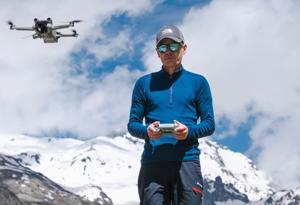
- UAS Operations Manager (for all UAS/Drone work)
- Providing support for GIS and mapping software in the GIS & Visualisation Suite
- Maintaining Geography and Archaeology equipment
- Providing support in lectures, field and classroom-based practicals
- Training in the use of field equipment and mapping software
- Deliver drone training courses to internal and external clients
- University First Aider
Training Profile
GIS & Mapping:
ESRI MOOC GIS Training courses (Various, 2019 onwards)
EDINA Digimap Training (2009 & 2018)
Trimble Geospatial Training (Various, 2018 onwards)
Surveying:
Trimble Survey GPS and TBC Software (2019 onwards)
Ground Penetrating Radar Course (2019)
Leica Terrestrial Laser Scanner Training (2015)
Archaeological Sample Processing – Floatation Tank Training (2012)
Geophysics Gradiometer Training (2011)
Acoustic Doppler Current Profiler Training (2008)
Geophysical Surveying Training (2008)
Geophysical Software Training – Geoplot (2008)
SonTek FlowTracker Discharge Measurement Training (2008)
Survey GPS Training Trimble (2007)
General:
First Aid at Work Certificate (St. Johns Ambulance, since 2007)
Train the Trainer Course (2019)
Recruitment & Selection HR Course 1 & 2 (2019)
COSHH Training (2011)
Health & Safety Training (2008 onwards)
Fire Safety Training (2008 & 2011)
GDPR Training (2023)
Diversity & Inclusion Training (2023)
SharePoint Training (2023) (2024)
Blackboard Training (2008) (2024)
Defensive Driving Qualification (Worcester, 2007)
Other:
EASA – European Pilot Qualification A1, A2 & A3 (2024)
GVC – CAA UK Pilot license (2023)
A2 CofC - CAA UK Pilot License (2023)
MIDAS – Driver Training (2024)
BNUC-S Pilot Qualification (2010)
Soil Mechanics Testing Course, ELE (2012)
University Roles
University Drone Officer
UAS Operations Manager
ESRI Software Administrator
UoW Staff Football Manager
University First Aider
Conferences & Workshops
Small UAS for Environmental Research Conference (2016)
SkyTech – Commercial UAV conference (2016)
Remote Sensing from Small UAV’s Workshop (2013)